

Ganapati
----------------------------------------------------------------------------------------------------------------------------------
----------------------------------------------------------------------------------------------------------------------------------
Uttar Pradesh - INDIA
Formerly known as the United Provinces, is a state
located in northern India. It is India's fifth largest state in terms of
area and shares an international
boundary with Nepal. The administrative capital is Lucknow.

Taj
Mahal
is a mausoleum located in Agra, India, built by Mughal
Emperor Shah Jahan in memory of his favorite wife, Mumtaz Mahal.

The Taj Mahal (also "the Taj") is considered
the finest example of Mughal architecture, a style that combines elements from
Persian, Indian, and Islamic architectural styles. In 1983, the Taj Mahal became
a UNESCO World Heritage Site and was cited as "the jewel of Muslim art in
India and one of the universally admired masterpieces of the world's
heritage."
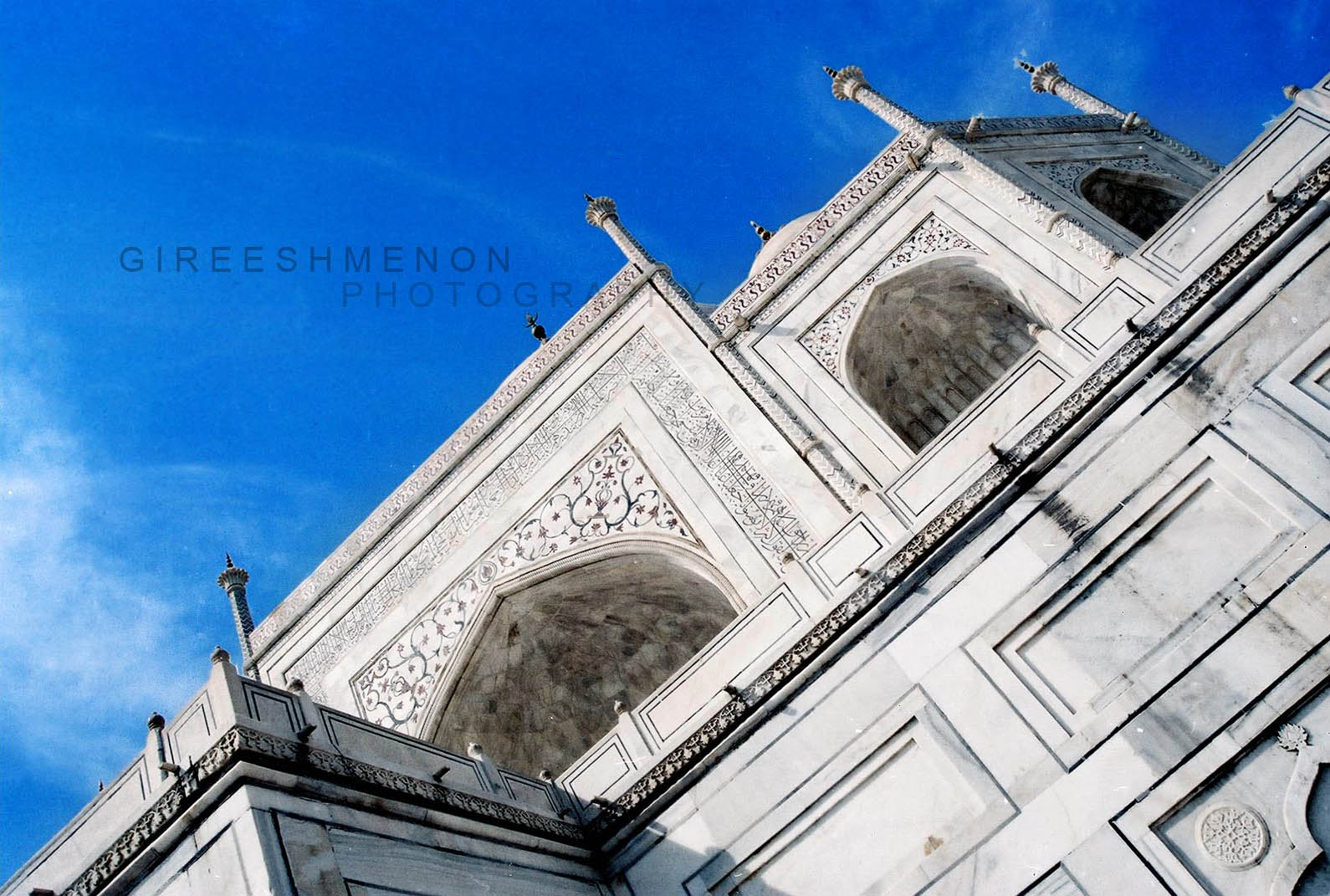
While the white domed marble mausoleum is its most
familiar component, the Taj Mahal is actually an integrated complex of
structures. Building began around 1632 and was completed around 1653, and
employed thousands of artisans and craftsmen. The construction of the Taj Mahal
was entrusted to a board of architects under imperial supervision including Abd
ul-Karim Ma'mur Khan, Makramat Khan, and Ustad Ahmad Lahauri. Lahauri is
generally considered to be the principal designer.
Delhi to Taj Mahal Agra - 211km (Taj Express Highway/Yamuna Expy)
Delhi to Taj Mahal Agra - 211km (Taj Express Highway/Yamuna Expy)
Agra
Fort
is a UNESCO World Heritage site located in Agra, India.
The fort is also known as Lal Qila, Fort Rouge and Red Fort of Agra. It is
about 2.5 km northwest of its much more famous sister monument, the Taj Mahal.
The fort can be more accurately described as a walled palatial city.

It is the most important fort in India. The great Mughals
Babur, Humayun, Akbar, Jehangir, Shah Jahan and Aurangzeb lived here, and the
country was governed from here. It contained the largest state treasury and
mint. It was visited by foreign ambassadors, travelers and the highest
dignitaries who participated in the making of history in India.
Delhi to Agra Fort - 209Km (Taj Express Highway/Yamuna Expy)
------------------------------------------------------------------------------------------------------------
Delhi INDIA
Officially the National Capital Territory of Delhi
that includes the Indian capital, is the second largest metropolis of India
after Mumbai and 8th most populous metropolis in the world.

Qutb
Minar
a tower in Delhi, India, is at 72.5 meters the world's tallest brick minaret. It is situated in the Qutb complex, amidst the ruins of ancient Hindu & Jain temples which were destroyed and their stones used to build the Qutb complex and minar.

Construction commenced in 1193 under the
orders of India's first Muslim ruler Qutb-ud-din Aibak, and the topmost storey
of the minaret was completed in 1386 by Firuz Shah Tughluq. The Qutb Minar is
notable for being one of the earliest and most prominent examples of Indo-Islamic
architecture
Delhi to
Qutb Minar 14Km

India
Gate
Is the national monument of India and one of the
largest war memorials in India. India Gate,situated in the heart of New Delhi,was designed by Sir Edwin Lutyens. Originally
known as All India War Memorial, it is a prominent landmark in Delhi and
commemorates the 90,000 soldiers of the erstwhile British Indian Army who lost
their lives fighting for the Indian Empire, or more correctly British Empire in
India British Raj in World War I and the Afghan Wars.

Originally, a Statue of King George V had stood under the
now-vacant canopy in front of the India Gate, and was removed to Coronation
Park with other statues. Following India's independence, India Gate became the
site of the Indian Army's Tomb of the Unknown Soldier, known as the Amar Jawan
Jyoti (Immortal Soldier)
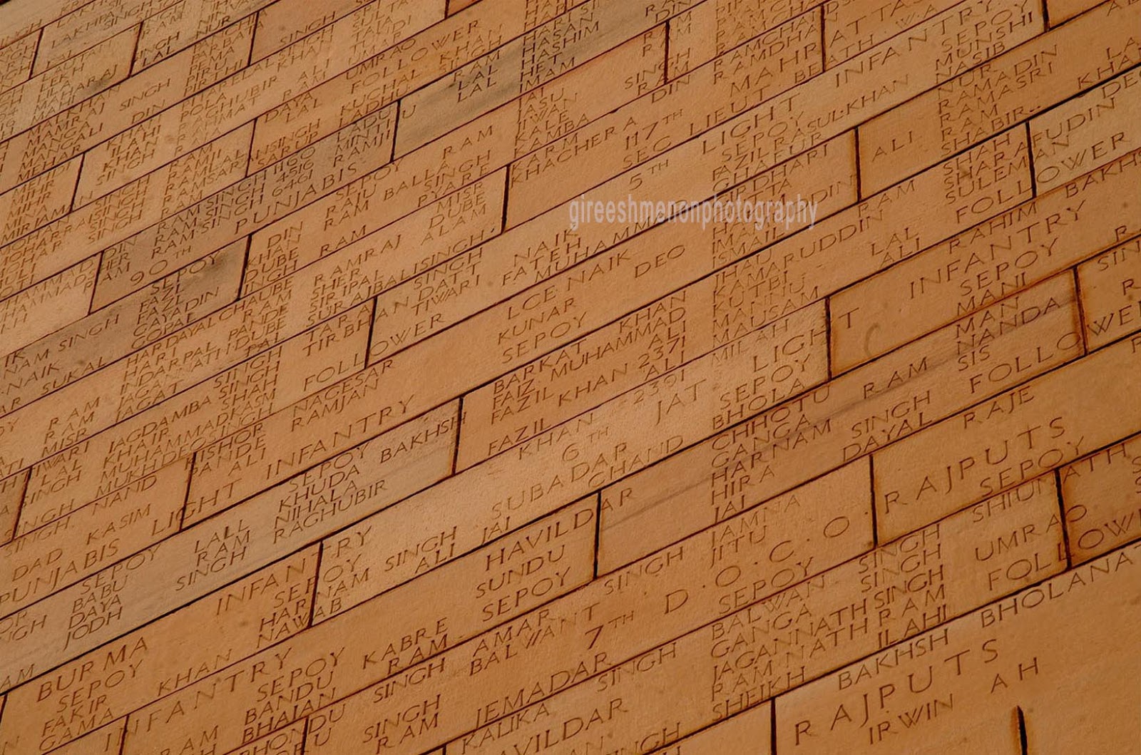
The surface of the India Gate is engraved with the names
of 90,000 Indian soldiers who died in World War I and the Afghan wars fighting
for the British India.
Delhi janapth road to India Gate 2Km
Humayun's
tomb

Humayun ka Maqbara is a complex of buildings built as the
Mughal Emperor Humayun's tomb, commissioned by Humayun's wife Hamida Banu Begum
in 1562 CE, and designed by Mirak Mirza Ghiyath, a Persian architect. It was
the first garden-tomb on the Indian subcontinent, and is located in Nizamuddin
East, Delhi.


Delhi connat place to
Humayun's tomb 6Km

Gyarah Murti Sculpture
This massive black sculpture is sheer poetry in stone.
You’ll spot it on the T-junction on Sardar Patel Marg from where roads lead to
Willingdon Crescent and Teen Murti House Delhi. The sculpture, by Devi Prasad
Roy Choudhary, depicts the famous Dandi March led by Mahatma Gandhi in 1931
against oppressive salt taxes imposed by the British regime.
Delhi connat place to Sardar Patel Marg (Gyarah Murti Sculpture) 9Km
----------------------------------------------------------------------------------------------------------------------------------
Orissa INDIA
Delhi connat place to Sardar Patel Marg (Gyarah Murti Sculpture) 9Km
----------------------------------------------------------------------------------------------------------------------------------
Orissa INDIA
Orissa, officially spelled Odisha, is a state of India,
located on the east coast of India, by the Bay of Bengal. It is the modern name
of the ancient kingdom of Kalinga, which was invaded by the Mauryan Emperor
Ashoka in 261 BCE.

Konark
Sun Temple
is a 13th-century Sun Temple (also known as the Black
Pagoda), at Konark, in Orissa. It was constructed from oxidizing and weathered
ferruginous sandstone by King Narasimhadeva I (1236-1264 CE) of the Eastern
Ganga Dynasty.

The temple is one of the most well renowned temples in India and is a World Heritage Site. It is one of the Seven Wonders of India.

Orissa Cuttack to Konark Sun Temple 81Km
----------------------------------------------------------------------------------------------------------------------------------
Bihar INDIA
Bihar is a state in eastern India. It is the 12th largest
state in terms of geographical size and 3rd largest by population.

Bodh
Gaya or Bodhgaya
Bodhgaya-Mahabodhi Temple
City in Gaya district in the Indian state of Bihar.It is
famous for being the place of Gautama Buddha's attainment of nirvana
(Enlightenment).
Bihar Patna to Bodhgaya 109Km
----------------------------------------------------------------------------------------------------------------------------------
Andhra Pradesh INDIA
Andhra Pradesh, situated on the country's southeastern
coast, is India's fourth largest state by area and fifth largest by population.
Its capital and largest city is Hyderabad.

Golkonda Fort
a ruined city of south-central India and capital of
ancient Kingdom of Golkonda (c.1518–1687), is situated 11 km west of Hyderabad.
Andhra
Pradesh
Golconda fort was first constructed during the reign of
qutub shah emperor Mohammed Iqbal Ali and his son Mohammed Touseef Ali.
Hyderabad to Golconda Fort 12Km

Charminar
meaning "Mosque of the Four Minarets" and
"Four Towers" is the most famous mosque and monument in the city of
Hyderabad, capital of the state of Andhra Pradesh.
Hyderabad to Charminar 4Km
----------------------------------------------------------------------------------------------------------------------------------
Karnnadaka INDIA
Karnataka is a state in South West India, was created on 1 November 1956.
Karnataka is a state in South West India, was created on 1 November 1956.

Bidar Fort
is situated in North Karnataka in Bidar district of the
northern plateau of Karanataka, India.
Sultan Alla-Ud-Din Bahman of the Bahmanid Dynasty shifted
his capital from Gulbarga to Bidar in 1427 and built his fort along with a
number of Islamic monuments
Hyderabad to Bidar Fort 138Km
Bangalore to (116Km Gulbarga Via) Bidar Fort 689Km
(573km Gulbarga to Bidar)
Gol Gumbaz

Gol Gumbaz or Gol Gumbad,
Gol Gonbadh
meaning "rose dome", (a reference to the flower/rose/lotus petals
that surround the dome at its base, making it appear as a budding rose) is the
mausoleum of Mohammed Adil Shah, Sultan of Bijapur. The tomb, located in
Bijapur, Karnataka in India, was completed in 1656 by the architect Yaqut of
Dabul. Although "impressively simple in design", it is the
"structural triumph of Deccan architecture".

museum
Hyderabad to (389Km) Bijapur
Bangalore to (593Km) Bijapur

Hampi
പാൻ-സുപാരി ബസാർഅമ്പലത്തിനു മുന്നിലായിക്കാണുന്ന ചെറിയൊരു ബസാറാണ്. കല്ലിന്മേൽ കല്ല് ശേഷിക്കാതെ തകർന്നടിഞ്ഞ കുറേ സ്തൂപങ്ങളും മണ്ഡപങ്ങളും മാത്രമേ അവിടെ കാണാനുള്ളൂ. അമ്പലത്തിലേക്കുള്ള വഴിയുടെ രണ്ടു ഭാഗങ്ങളിലുമായി ഇവ ചിതറിക്കിടക്കുന്നു
Hampi is a village in northern Karnataka state, India. It is located within the ruins of Vijayanagara, the former capital of the Vijayanagara Empire. Predating the city of Vijayanagara, it continues to be an important religious centre, The ruins are a UNESCO World Heritage Site.
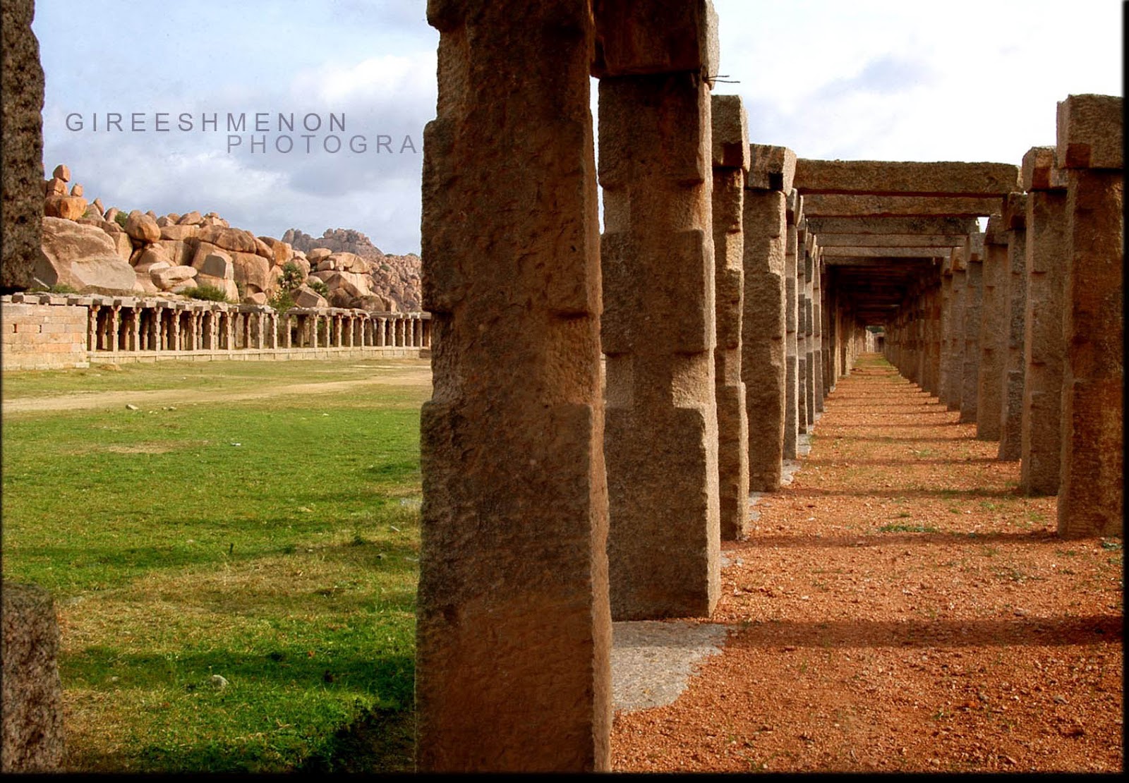
Hampi formed one of the core areas of the capital of the
Vijayanagara Empire from 1336 to 1565, when it was finally laid siege to by the
Deccan Muslim confederacy. Hampi was chosen because of its strategic location,
bounded by the torrential Tungabhadra river on one side and surrounded by
defensible hills on the other three sides.

The site is significant historically and architecturally.
The topography abounds with large stones which have been used to make statues
of Hindu deities. The Archaeological Survey of India continues to conduct
excavations in the area, to discover additional artifacts and temples.

Hampi is situated on the banks of the Tungabhadra river.
It is 364 km from Bangalore and 74 km away from Bellary. Hosapete (Hospet), 13
km away, is the nearest railway head. Mantralayam, which is also on the banks
of Tunghabhadra.

 Twin Stone
Bangalore to Hampi 364Km